RANTINGS AND RAVINGS OF AN OLD MAN TRULY RUINED BY SPORT

Thursday, November 11, 2010

Upland Bird Hunting: Huns Are Where You Find Them

(click to enlarge)
I can't say if Montana is best Hungarian partridge hunting in the country but one thing sure there's a helluva lot of it. Huns live just about everywhere, north to south, east to west, and, except for the very highest peaks all elevations. If I had to guess the biggest continuous chunk of Hun country is in that vast grass and wheat country roughly north of Great Falls, east to Havre and north to the Canadian line. Ideal Hun habitat consists of rolling grasslands, bordered by extensive grain fields, handy to water...and since those pretty much define this part of Montana...well I rest my case.

(click to enlarge)

Huns arrived in the U.S. sometime around 1900, most biologists agree the birds simply drifted down from Alberta and Saskatchewan, found things to their liking and spread out from there. For reasons known only to MTFWP, as well as other state agencies, other than resetting the same bag limits year after year Huns are not managed, rather mostly left alone to fend for themselves. Obviously this works sort of like if it ain't broke why fix it. Though I suspect the real reason is Huns really are tough, resilient, get along quite well just about anywhere so long as overhead cover is on the low side and more or less treeless and barring really bad weather extremes numbers remain just about the same year after year. Unlike other upland birds with Hun coveys so long as there are no drastic changes to the habitat use the same spots year after year. And of all the upland birds none are more structure oriented...a certain fence corner, abandoned homestead, ranch junkyard, one covey we've hunted for years hangs out on one side of a narrow rocky ridge, never the other. 
Another constant seems to water, not necessarily right beside it but at least within reasonable flying distance. And while grain is obviously welcome there are many coveys out there whose members live and die having never tasted it.

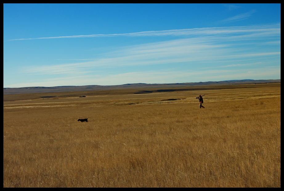
I suppose you could hunt Huns without a dog, and certainly there are flushing dogs get the job done but...I'll take a pointing dog anyday and the bigger the dog runs the better. Hun country (see the above photo) is big country and the way I see it the more ground the dog covers the less wear and tear on my old, rickety knees so...Of course it is imperative the big running dog is seasoned and steady since points often come way, way out there. Huns usually flush as a covey and stay together. Some days they hold like Mearn's quail others as wild as the late season sharptail grouse often share living space. It is often possible to follow up and flush a covey multiple times--my record is 4 but I've read of more. Be aware most coveys do not stay in the landing zone long and some run quite a ways. If Huns land on a side hill you can almost bet the farm they will run over the top before stopping. It seems me with each flush the birds hold tighter but I can't prove it so...

Hun guns and loads are a matter of personal taste but I've found a 20 ga. loaded with an ounce of 7 1/2s shoved through Improved Cylinder choke tubes to work pretty good. Montana Hun season runs September 1 thru January 1. The daily bag limit is 8 per and has been for as long as I can recall.

One of the best things about hunting Huns is, unlike Montana's national bird, you Will Never find a crowd...guarandamnteed. Also you will almost Never be denied access to private, that is so long as its not leased to outfitters And do put considerable distance between you and our bigger towns and cities

Wednesday, November 10, 2010

Travel: Adrift in the Sweet Grass Hills, MT

(click to enlarge)

On a clear day Gold Butte and the rest of the Sweet Grass Hills in northcentral Montana dominate the northern horizon and are said to be visible from as far away as 150 miles; while we can't confirm or deny that we can say "the distance is mind-boggling, much farther than we at first suspected."

The reason for this is of course the buttes--West, Gold, Haystack and East--jut up about 2000 feet above the surrounding, relatively flat High Plains.

The Sweet Grass Hills are located north of US 2 (HiLine) northeast of Shelby and northwest of Havre just a few miles from the Canadian Border. 

Trees are scarce, largely confined to the buttes themselves. With nothing much taller than the namesake grass to block it the Hills are notoriously windy--even on those rare calm days on the surrounding prairie you can bet the wind will kick up here.

(click to enlarge)


(click to enlarge)

Big and empty beyond imagination ranch and farm buildings are few and far between--as such tourists are rare and the few folks you do encounter are almost sure to be ranchers, farmers or hunters. Judging the size (the main structure is about 10 X 10) of this long ago abandoned one-room school house (Hill County School, circa 1910) in past times might have even been emptier.

Prior to settlement the Hills were Blackfeet Indian territory. Considered a sacred area, extensive petroglyphs can be found carved into the sandstone bluffs.

The area also holds a prominent place in the history of the Royal Canadian Mounted Police. In the 1870s Mounties were dispatched from eastern Canada in an attempt to bring order to the area and put an end to the whiskey trade with the Indians. White traders, mostly from the Fort Benton area, were doing a brisk business trading whiskey with the Blackfeet. Eventually successful the Mounties were at first woefully unprepared and somewhat ignorant of the challenges before them. One account tells a harrowing tale of the troops being hopelessly lost and near death in the country north of West Butte. Knowing Fort Benton was somewhere to the south, two were dispatched in a desperate attempt to get help. Ironically the very traders the troops were sent to end the whiskey trade, sent supply wagons north and the party was rescued.

Not long after the whiskey trading days, gold was discovered in the vicinity of Middle Butte. The town of Gold Butte quickly sprang up and boomed for a time. Eventually the town was abandoned, cattlemen bulldozed the buildings and all that remains today is a cemetery and scattered mining debris.

The public land is primarily BLM, and a few scattered State sections; the BLM land is managed as a Special Recreation Use Area.


Tuesday, November 9, 2010

Travel: Upper Missouri Breaks National Monument Interpretive Center, Fort Benton, MT

(click to enlarge)

In 1976, Congress designated 149 miles of the Missouri River in Central Montana as Wild and Scenic. The added exposure drew visitors from around the country and recognition as a national treasure soon followed. Not only among the best preserved examples of Central Montana Prairie Ecosystems the river corridor was a premier segment of the Lewis and Clark National Historic Trail, as well as a significant segment of the Nez Perce National Historic Trail. Remote and still wild the corridor provides habitat to a wide variety of wildlife-some threatened and endangered.


In response to requests from Montanan's and others who had visited the area and were awed by its beauty and remoteness, Interior Secretary Bruce Babbitt toured the area in May 1999 with Senator Max Baucus, author/historian Stephen Ambrose, and author Dayton Duncan. Following Babbitt's trip, the Central Montana Resource Advisory Council (RAC) held meetings throughout all the towns in the area over a five-month period and developed recommendations pertaining to management that were sent to the Secretary in December 1999. More than 800 pieces of testimony were collected by the RAC and reviewed by the Secretary. Local and national support for National Monument designation was overwhelming. Babbitt's office consulted with the Governor and the Montana delegation throughout the process.

Babbitt returned in the spring of 2000 and held another meeting with the RAC and members of the public. In June 2000, Babbitt met with the Montana delegation in Washington, DC to discuss the status of the proposal, legislative options, and the importance of holding true to the recommendations of the Resource Advisory Council.

Opposition to the Monument came from individuals and organizations who had economic and personal interests in maintaining the status quo. These included local ranchers with grazing leases, oil and gas companies with leases or the desire to hold leases within the proposed Monument, and motorized vehicle users who believed that the Monument designation threatened their recreational activities. Some ranchers organized into a group called the Missouri River Stewards. They asserted that their livelihoods and historic use of the public’s land would be harmed by the Monument designation.

However, despite howls of angry protest, on December 22, 2000, Secretary Babbitt recommended to the President Clinton that the area be designated a national monument. It became official on January 17, 2001.

Unlike other national monumets which are managed by the National Park Service the UMBNM is managed by the Bureau of Land Management (BLM). This was done to avoid stirring up more debate as other national monuments are managed consistent with the mission of the Park Service and some traditional uses would be eliminated. Secretary Babbitt had something different in mind for this “crown jewel” of BLM land, as well as others which he called “landscape monuments.” His vision was to give the BLM the primary role of managing and preserving these areas for future generations and thereby shift the culture of the BLM toward managing for preservation of these special landscapes rather than serving as an agent for the extraction industry as has been widely hinted in the past.

(click to enlarge)

Besides providing visitors information on the Monument itself there is much to learn about the flight of the Nez Perce some of the conflicts with the U.S. Army who pursued them. Here Gale is reading about the so-called Cow Island Incident. On September 21, 1877 13 Fort Benton troops, of Company F, 7th Army, and two volunteers loaded a canon onto a steamship. Aided by 38 volunteers on horseback they headed downriver to defend Fort Claggett and protect the supplies at the Cow Island steamboat landing from a band of Nez Perce reported to be heading that way.

Too late they found the supply wagons had already been looted and burned. Outnumbered the troops and volunteers turned tail and returned to Fort Benton.


(click to enlarge)

In addition there is also much to learn concerning the often hazardous steamboat journeys, what the early days in Fort Benton were like and many other interesting tidbits of what really was one of the more fascinating tales in Montana history.